|
DEEP PECULIARITIES OF THE COLLISIONAL GRANITOIDAL MAGMATISM IN THE AMUR AND EURASIAN LITHOSPHERIC PLATES JUNCTION ZONE Yu. A. Kosygin Institute of Tectonics and Geophysics FEB RAS, Khabarovsk, Russia shevchenko@itig.as.khb.ru
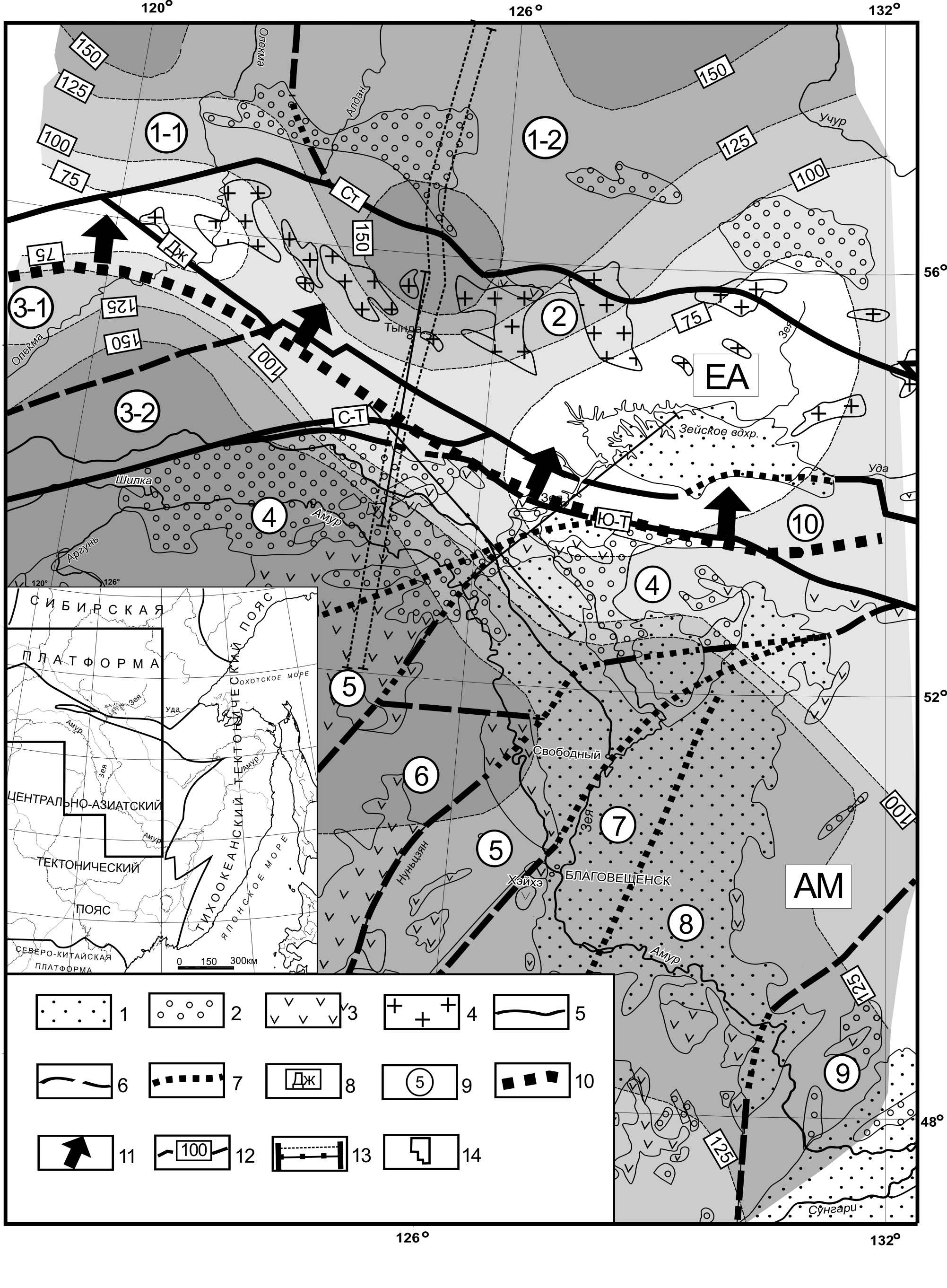
Modern tectonic plates of the continental lithosphere are composed of tectonic elements of different age. Particularly, the Amur plate is formed, in the first place, by the Paleozoic and Mesozoic orogenic structures (Parfenov, 2003). Mesozoic magmatism is widely spread in the entire of its area. It is represented to a significant extent as by volcano-plutonic belts (VPB) so by granitoidal intrusive belts (Romanovskii, 1999). Further geochemical and geochronological studies (in the first place, along the northwestern and northern boundaries between the Amur and Eurasian plates) provided verification of the time parameters of the granitoidal belts. These studies allowed the assumption on a rather continuous collisional process of the Amur super terrane (the Amur paleoplate). After closure of the Mongolo-Okhotsk Ocean the northern boundary between the plates was formed no later than the Early Triassic at its western and central segments and no later than Mid- and Late Jurassic at the eastern one (Sorokin, 2005). The Amur plate has been formed in its contemporary structure no later than Middle Miocene (Fundamental problems…, 2001). In all probability, duration and discreteness of the collisional process occurring between the Amur and Eurasian lithospheric plates led to the fact that the granitoidal magmatism differs as to its petrochemical and petrophysical parameters within the plates and at their boundaries. It should be expected that deep characteristics of the crust, in particular, and the lithosphere, entirely, will be distinguished by specific peculiarities. The Late Jurassic-Early Cretaceous Stanovoy batholith belt was chosen for the study. The belt is located within the Stanovoy granite-greenstone area (Tectonics, deep…, 2005). The age of one of the batholiths of this belt is 1271 Ma (Sorokin, 2005). There have been constructed 3-D models of the surface of the crust and of the lithosphere, 3-D and 2-D-density models, data on geoelectrical modeling of results of magnetotelluric soundings were involved. It follows from the analysis of 3-D depth model that the Stanovoy batholith belt passes along the deep boundary between the Amur and Eurasian tectonic plates (Fig. 1). Plane of boundary dipping is directed beneath the Eurasian plate, and the batholith belt is controlled by this deep element of the lithosphere. The thickness reduction of the lithosphere to 60-70 km is characteristic of the belt, the seismic conversion wave boundaries are absent at the lithosphere-asthenosphere boundary (depths to 120 km). This phenomenon testifies to the fact that up till now the substance of the lithosphere is in a more plastic state in this area. Probably, these areas caused the formation of the collisional granitoids within the crust along the boundaries of tectonic plate junction.
Sedimentary basins: 1 - Cenozoic, 2 - Mesozoic; 3 – fragments of Mesozoic volcanites; 4 – Mesozoic collisional granites of the Stanovoy batholith belt; faults: 5 - interblock, 6 - intrablock, 7 – those overlain by sedimentary deposits; 8 – names of faults: St – Stanovoy, Dzh - Dzheltulak, N-T – North-Tukuringra, S-Т- South-Tukuringra. 9 – numbers of main tectonic structures (Aldan-Stanovoy Shield: 1-1 - Olekma granite-greenstone area, 1-2 –Aldan granulite-gneiss area; 2 – Stanovoy granite-greenstone area. Central Asian Tectonic Belt: block of the Selenga-Stanovoy Caledonian orogenic belt: 3-1 - Tungir, 3-2 - Mogocha; 4 – Argun-Mamyn massif (microcontinent); 5 – North Hinggan Caledonian orogenic belt; 6 - Jiagdachi massif; 7 - Silamulun-Yienben Hercynian orogenic belt; 8 - Turan-Zhangguangcailing massif (microcontinent); 9 - Jiamusi-Malohinggan massif (microcontinent); 10 – Mongolo-Okhotsk Late Paleozoic-Mesozoic orogenic belt); 10 – contemporary boundary of tectonic plates convergence (EA - Eurasian, AM - Amur); 11 – dipping direction for the boundary of plate convergence; 12 – isopachs of the lithosphere, km; 13 – line of the profile under study; 14 – outline of the study area on the tectonic zoning scheme (insert). The structure of the depth section and the calculated geophysical parameters, up to the outcrop at the surface, affirm the assumption made: Areas with increased electric conductivity are determined within the lithosphere (70-90 km depths) and at the crust-mantle boundary (37-42 km depths). On the whole, it is observed specific echeloning of the anomalous seismic and geoelectrical anomalous objects by depth. Farther, within the crust, this specific column is distinguished by the calculated density values. Within the lower crust (20-40 km) it is a value of 2.86 g/cm3 at the background of 2.91 – 2.92 g/cm3, in the upper crust (10-20 km) – 2.77 g/cm3 at the background of 2.86 g/cm3 and in the upper crust (0-10 km) – 2.74 g/cm3 at he background of 2.77 – 2.86 g/cm3 (Tectonics, deep…, 2005). The similar deep density structure is traced along the strike of the batholith belt under study. The work is supported by the grant of the Russian Foundation for Basic Research 07-05-00726 and grant of the Far Eastern Branch, Russian Academy of Sciences 06-1-DES-110.
References Parfenov L.M., Berzin N.A., Khanchuk A.I. et al. Model of the formation of orogenic belts of Central and Northeastern Asia //Tikhookeanskaya geologiya, 2003. V. 22. No. 6. P.7-41. (in Russian). Romanovskii N.P. Pacific segment of the Earth: deep structure, granitoidal ore-magmatic systems. Khabarovsk: ITIG DVO RAN, 1999. 167p. (in Russian). Sorokin A.A. Geodynamic evolution of the eastern segment of the Mongolo-Okhotsk foldbelt. Saint-Petersburg: IGIG of Precambrian, RAN, Sc. D. (Geol. & Mineral) Thesis, 2005. 48p.(In Russian). Tectonics, deep structure, metallogeny of the Central Asian and Pacific belts junction area (explanatory notes to the Tectonic map scale of 1: 1 500 000), Vladivostok – Khabarovsk: DVO RAN, 2005. 264p. (in Russian). Fundamental problems of tectonics. M.: Nauchny mir, 2001. 520p. (in Russian).
|
